 This Wiki is licensed

- Loading...
- No images or files uploaded yet.
Attribution-Noncommercial-Share Alike 3.0 License. Authors, learn more about your rights.
The Fort Leavenworth-Fort Gibson Military Road ...www.kancoll.org/khq/1942/42_2_barry.htm
digitized with permission of the Kansas State Historical Society.... The route of the Western military road, approved by congress in 1836,... 1841, requested a report from the Secretary of War on the frontier military strength and the ...
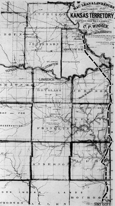
54. As originally surveyed in 1837, the entire section of the frontier military highway later known as the Fort Leavenworth-Fort Scott military road ran west of the Missouri state line. Maps of the latter 1850's show the road within R. 25 E from Fort Scott north to northern Johnson county before it turned northwest to Fort Leavenworth, but these maps vary considerably in locating certain portions of the highway.
The Whitman and Searl "Map of Eastern Kansas," published in 1856 independently of the public surveys then in progress, traced the road entirely within Kansas territory. Almost all the later maps (1857 to 1860) were compiled from land office surveys but they show variations of as much as five or six miles in certain sections of the route. Some traced the road into Missouri for a very short distance at the Johnson-Lykins (Miami) county line, and nearly all ran it into Missouri for a mile or two at the Lykins-Linn boundary (see cut opposite p. 129).
The available Kansas maps of the 1850's do not show the road running south from Fort Scott toward Fort Gibson and Arkansas. This was because the region south was Indian land. It was not until the latter 1860's when these Indians by treaties began to give up their lands in exchange for other reservations and concessions that this portion of Kansas was surveyed. The first plats for this area in the office of the state auditor are dated in 1866 and 1867.
The surveyors designated the highway as the "Military Road and Fort Scott to Ark.," tracing it near the Missouri border through Crawford county, passing through the present towns of Arcadia and Mulberry. In Cherokee county the road swung a few miles to the west and left the state south of Baxter Springs.
Although the military highway as shown on these plats may have little relation to the road of the 1840'd, it nevertheless seems likely that some sections of the original were retained in subsequent highway changes.
Rep. F. A. Jewell, Bourbon county, introduced a bill in the 1917 legislature to provide an appropriation "to write and publish a history of, and mark with monuments, the old military road in the state of Kansas. . . ." The proposal was turned down in committee. --- See House Journal, Kansas, 1917, pp. 236, 360. |
|
To join this workspace,
request access.
Already have an account? Log in!
Please preview WhatWikiIsAlso see shared files uploaded here:http://fmhb.pbworks.com/w/browse/#view=ViewAllFiles
This is your Sidebar, which you can edit like any other page in your workspace.
This Sidebar appears everywhere on your workspace. Add to it whatever you like -- a navigation section, a link to your favorite web sites, or anything else.
geoWIZard Pathfinder Passports:Bob RJ Burkhart
Two decades after its first publication, Roadside Kansas remains the premier guide to the geology, natural resources, landmarks, and landscapes along nine of the Sunflower State’s major highways.
During that span, however, many aspects of the Kansas landscape changed:the growth of some towns and near disappearance of others, the expansion of highways, the development of industry.
Even the rocks themselves changed in places as erosion took its relentless toll.
More broadly, there have been changes in the science of geology.
This new edition reflects all of these changes and thoroughly updates the previous edition in ways that reinforce its preeminent status.
Order from http://digitaljaywalker.net/ (Deactivated) |
Comments (1)
Bob-RJ Burkhart said
at 7:34 pm on Jun 3, 2012
Frontier Army Quartermaster overland cargo wagon routes followed glacial hills ridge lines (high ways) @ http://fmhb.pbworks.com/w/page/53848863/FMHB%20TravelKS%20Watersheds
You don't have permission to comment on this page.